Saturday, 8 November 2014

Bynack More.

Abhainn Ruigh-eunachan near Allt Mor Car Park

The days are drawing in. This one looked like a longish walk on paper, but the paths are renowned for being good, so we thought we'd make good time... 


The Ryvoan Pass from Glen More

An early start from the Forestry Commission car park at Allt Mor gave us plenty of daylight - and what a lovely day - the sun, low in the sky, catching the hilltops and shining through the Scots pine.

There were a few twists and turns and branching's off through the forest, but a couple of double checks of the map, and we were soon on the main track that leads up from Glenmore Lodge and goes up through the Ryvoan Pass. (It's part of the Thieves Road from Glen More to Nethy Bridge) 


Caledonian pine forest, Glen More
The sun wasn't yet on the waters of An Lochan Uaine, famous for its turquoise-green waters, so we didn't quite get the full effect - but it was certainly a beautiful spot...


An Lochan Uaine

The path led us further east, over the Pass, through more gnarled and ancient Caledonian pine forest and into Strath Nethy, expansive views across high rolling moorlands, with the high Cairngorms to our south.


An Lochan Uaine from the Ryvoan Pass

The Lairig an Laoigh heads south from the Ryvoan track just before the bothy - if time any daylight allowed, we'd stop off for a visit there on our return...


Not much chance of getting lost (NJ003111)
Lairig an Laoigh or Theives' Road
The Lairig an Laoigh was our route for the next few k, winding and undulating through the open moorland, the views opening up all around as the sun climbed higher.


Rafe and Jim
Lairig an Laoigh path near Loch a Gharbh-choire (NJ00511)

The path was excellent, and with not much in the way of ascent as yet, easy walking.


Looking back to Ryvoan Bothy and Lochan a'Chait from the Lairig an Laoigh path 

Rafe and Jim - On the Lairig an Laoigh path,
skirting the northern end of An Garbh-choire

We passed the site of the Bynack Stable beside the Allt a'Garbh-coire - nothing left of the old hut that once was used as a shelter in emergencies - it finally collapsed in 2005... 


The River Nethy and Strath Nethy
Before crossing the River Nethy on a good bridge.


The River Nethy - footbridge at NJ021105

And here the ascent started - but it wasn't hard going - it was gradual and on a good path. If Rafie had been a few years younger, it would have been an excellent bike ride.


Rafe and Jim on Lairig an Laoigh - ascent of Bynack More

There were a few other walkers about - some doing various training from Glenmore Lodge. Everyone stopped for a word, cheerful in the late autumn sunshine.


Looking back along our route and to Meall a'Bhuachaille

Once we made it to over the first rise to the broad plateau before Bynack More, we had our first proper viewing of the mountain ahead, with its smaller brother, Bynack Beg next door.


Jim and Rafe - Bynack More and Bynack Beg

We continued on the Lairig an Laoigh path across the plateau, the hills rising before us, blinded by the sun...


North to Moray from Lairig an Laoigh on the moor below Bynack More

The moor behind us was almost featureless, the path meandering through the bleached vegetation, blasted by the harsh winters up here - bleak - but beautiful non the less.


Rafe and Jim - Bynack More and Bynack Beg

As we neared the summit of the moor (818m) our path left the Lairig an Laoigh and made a bee line for Bynack More.


Jim - A good place for a spot of lunch - below Bynack More

Just before we got to that final summit pull, we decided that some refreshment was in order and took a short detour east, into some rocks (NJ043075 approx) to get out of a chilly wind that was getting up. 
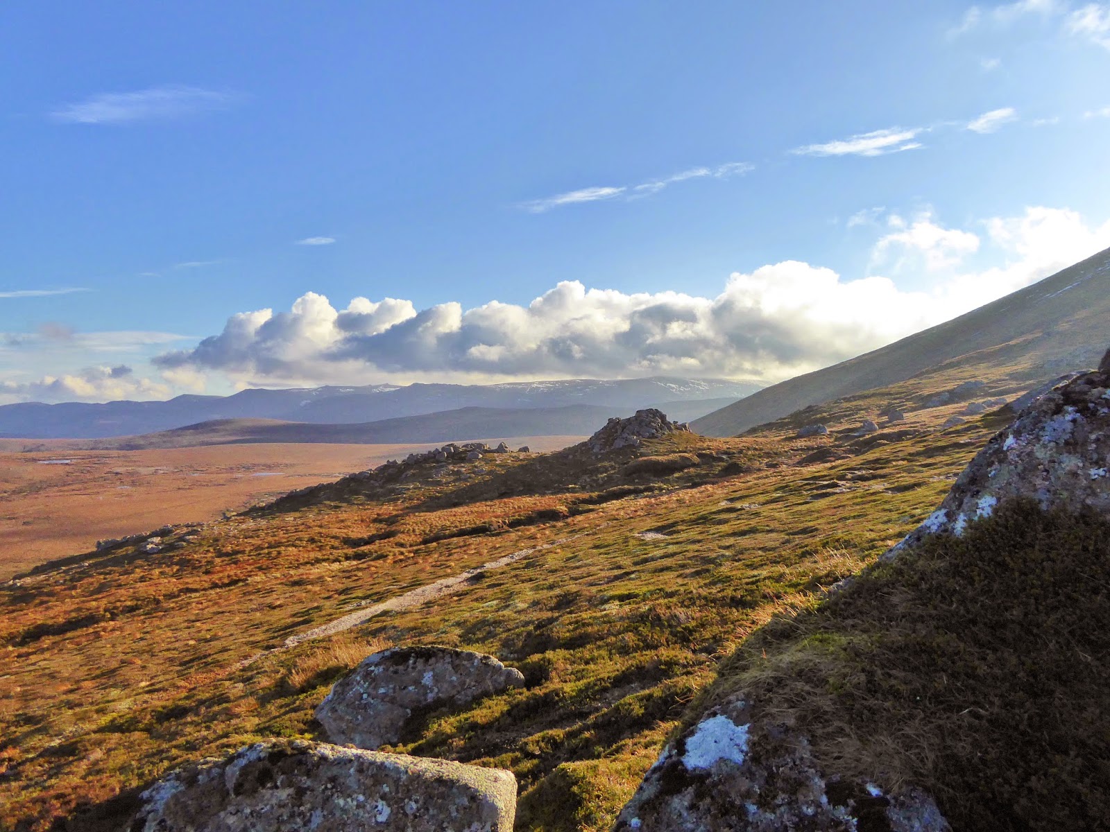

Views south east from below Bynack More - picnic view!

A sandwich always tastes better when it goes with a glorious view!


Views north from ascent of Bynack More

Once back on the path (and after some sustenance!) the 200m or so of ascent left to the summit flew by...


Jim - Ascent of Bynack More

There were a few rocks and a bit of snow, but we were ready for something to get our boots into.


Views north over Moray from Bynack More

It was clear and cold - the views went on forever.

North, we could see right across Moray - we were fairly sure that we could see our house - honest!


Bynack More summit plateau

The summit was a jumble of boulders - the highest point was towards the south end of the summit ridge, denoted by the usual pile of rocks.

The views to the south and west from Bynack More (Munro 54, 1090m) were towards the high tops of the Monadh Ruadh - Cairn Gorm, Ben Macdui, Breariach, et al. Today the cloud skimmed the highest summits, lit from behind by the afternoon sun and highlighted by a sprinkling of early snow - it was hard to identify individual peaks - it didn't matter... 


Jim - Bynack More summit (Munro 54, 1090m) - views south

Time was getting on. 

We had decided to pick up the Munro Top of Bynack Beg, so back along the summit plateau,..


Bynack Beg from Bynack More with Meall a'Bhuachaille beyond

...an easy descent to the north west and over a grassy bealach...


Jim descends towards Bynack Beg

...took us to Bynack Beg (Munro Top 120, 970m).


Bynack Beg (Munro Top 120, 970m)
With more wonderful views over Moray and today's route.


Bynack More from Bynack Beg

There was some discussion regarding our descent route.

Jim wanted to head north west, straight off the nose of Bynack Beg - now I might have been up for this, had it not been mid afternoon and had I not read the guide book which discussed the demerits of the Stath Nethy bogs. We did have a bit of a recce descent to an agreed boulder to see what it looked like. Jim finally came round to my way of thinking when we saw the afternoon sun glinting on the pools in the waterlogged glen, with a distinct lack of any path visible!!

So it was decided (!) that we would make our way around the coire, back to our ascent route, and head back that way...


Jim and Rafe
Countouring around Coire Dubh below Bynack More

We trudged back up to the summit of Bynack Beg, before contouring around the head of Coire Dubh, through tussocks and over a few little burns. Rafe got a drink and a plodge below a little waterfall, before we crossed back over the featureless moor to the Lairig an Laoigh path. 


Jim and Rafe - Descent from below Bynack More

Once on the path, the descent was easy, smooth and fast - and we were given motivation to get on with it, by ominous clouds gathering over the mountains and marching up Strath Nethy. Would we get wet?


South into Strath Nethy 


Rafe and Jim - Descent from Bynack More - on the Lairig an Laoigh

Bynack More and Bynack Beg above Strath Nethy

Back at the track junction with the Ryvoan Pass path, we took a right and walked the 500m or so, along the rather bouldery track, to the lovely, reputed to be haunted, little Ryvoan Bothy. A great place for a second lunch - and a chat with a young family also having a break in the old farmhouse. They had climbed Meall 'Bhuachaille and the children were feeling particularly proud of themselves - and so they should!


Ryvoan Bothy

After we had taken in a few calories, we moved on, back to the track junction and back over the Ryvoan Pass. 

The sun had gone down by the time we reached An Lochan Uaine, but it was bright - the waters were still, clear and very green - we'll be back again to try and catch it in the sunlight.

Rafe didn't care what colour it was - he just wanted in!

We were back at Allt More just as it was starting to get dark - there's nothing like the smell of wet dog in the car...


Rafe by An Lochan Uaine

Route:  Allt Mor car park (NH983088), path SE (initially purple route), over fb (NH984085), track E, cross bridge (NH989088), track NE, cross ford (NH992091), track N over fb to track junction (NH992097), track E through Ryvoan Pass to track junction (NJ003111), E (sp Braemar), along Lairig an Laoigh to fb over River Nethy (NJ021105), good path E up shoulder (not by river) to sh 818m, Bynack More (Munro 54, 1090m), NW to Bynack Beg (Munro Top 120, 970m), return SE to bealach (NJ037065) and contour NE round Coire Dubh to meet outward path near sh 818m, return on outward path to junction at NJ003111, NE to Ryvoan Bothy, return SW to track junction (NJ003111) and retrach outward route to start.

Statistics:  Distance: 25km  Ascent: 900m  Time: 6.45hours

Map:  OS Explorer 403 (Cairn Gorm & Aviemore)

Bynack More

Saturday, 1 November 2014

Sgor Gaoith.

Rafe as we set off from the
Invereshie and Inshriach Nature Reserve car park (NH852012)

The hour has gone back and the daylight hours are lessening...

The forecast was for better weather in the east today - so the Cairngorms seemed a better bet for good views - even if the winds were due to get up later in the day.

So it was an early start from the campsite, making it to the car park at the beginning of the walk for 9;15am. We went for a shorter, one Munro, walk today, wanting to give ourselves plenty of time to get off the hill before dark. Sgor Gaoith was our main aim, with three Munro Tops as a bonus (apparently all three used to be Munro's but were demoted as being subsidiaries).

Ascending through the pine forest of Invereshie and Inshriach Nature Reserve

The guide book gave a rather over complicated explanation of the initial part of the walk in the woods - it was absolutely straightforward and obvious - an excellent path through the beautiful regenerating pinewoods of the Invereshie and Inshriach Nature Reserve. Even though the skies were rather grey, the autumn colours glowed...

The excellent path through the autumn grasses as we contour around
Meall Tionail

I would have quite liked to be in the woods a little longer, but after crossing the Allt nam Bo and soon after the Allt Coire na Cloiche, (only small burns today, even after all the recent rain) we headed out onto the open hillside, across the lower slopes of Meall Tionail. The path contoured around the hill, gaining height only very gradually - it almost looked like an all access path - a little bit too engineered and it certainly stood out in the landscape!

The autumn colours shone out - the grasses, bright orange, thrashing about in a squally shower that passed over,

Allt a'Chrom-alltain looking east to Carn Ban Beag

By the time we reached Allt a'Chrom-alltain, the rain had stopped (I had been on the point of donning full waterproofs - nothing worse when the route is just about to get steeper and hotter!).

Once over the burn the path deteriorated markedly - to muddy, slimy, messy stuff.

We were gaining height though - we were soon on a flat shoulder at about 810m with great views over the nature reserve and beyond to the Spey Valley. The hills roundabout were green, grey and orange in the late autumn light, smooth and rolling - with the bigger hills to the west merging into angry cloud...

Ascent to bealach south of Sgor Gaoith - views north west

We continued on up, the path disappeared completely for a few hundred yards as we headed south east towards the bealach south of Sgor Gaoith. The path suddenly reappeared as if it had never been away - its amazing how much faster you walk when on a (reasonably) smooth path, rather than vegetation!

Sgor Gaoith from the  plateau to the south of the summit

We soon popped up onto the wide bealach and turned north towards the Munro. A very gentle ascent took us towards the summit, with massive cliffs, cories and buttresses to the east of the plateau, so very different from the rolling greens so far...

Loch Eanaich from the top of Coire na Callich, south of Sgor Gaoith summit
Views east to Braeriach

Loch Eanaich, steel grey/blue below and the enormous Braeriach massif east over the gleann.

Sgor Gaoith southern top

The wind was noticeably stronger, we were at over 1100m now, it was a touch chilly. Sending Jim on ahead to the summit for a photo op seemed like to good idea, but just a few minutes standing about and I was chilled to the bone!

Loch Eanaich and Braeriach from Sgor Gaoith southern top

The views, though, were amazing - Braeriach loomed, the cliffs yawned and the wind whined - totally atmospheric - I'm afraid the photographs don't do it justice, the light just wasn't quite right for my photographic skills (or lack of) today...

Sgor Gaoith - Loch Eanaich and Braeriach

The second summit was the highest, just the few extra metre's seemed to add to the wind's strength - it felt quite hairy close to the edge. After a few more photo's on the summit of Sgor Gaoith (Munro 36, 1118m) we took ourselves off the very top into the relative shelter below.

Rafe and Jim - Sgor Gaoith summit (Munro 36, 1118m)

We followed the cliff edge north from the summit into another wide bealach at 1053m and then dropped just over to the east out of the worst of the wind.

Sgor Gaoith summit with views south east to Loch Eanaich

A spot of lunch was in order. Despite donning an extra layer, it was not the warmest picnic we have ever had, and was therefore, rather short-lived!

Gleann Eanaich from the descent from Sgor Gaoith

Sgor Gaoith from the bealach to the north (spot height 1058m)

We were quickly on the move again - keen to get warmed up with a bit of ascent. The short pull up Sgoran Dubh Mor (Munro Top 18, 1111m) warmed us up, but the wind on the summit plateau was wild - it was one of those times when you need to lean into the wind to make any progress and pausing during the worst gusts is obligatory if you don't want to get blown over!

Rafe and Jim - Sgoran Dubh Mor (Munro Top 18, 1111m) - Views south to Sgor Gaoith

Very little time was spent on Sgoran Dubh Mor's summit. A quick descent directly down grass and boulders to the bealach to the south east, took us out of the worst of the gale, but it was obvious that the forecast had been right and the wind was getting up.

Rafe and Jim - Meall Buidhe (Munro Top 111, 978m)

Any path had pretty much gone now, but the way was clear, another short ascent to the twin summits of Meall Buidhe (Munro Top 111, 978m), where the wind was howling again, It was blowing in from the south, or from our left, pushing us across the summit plateau, it would have been rather nasty if we had been on any pointy stuff!

Sgoran Dubh Mor and Sgor Gaoith from Meall Buidhe

The sun had come out though... Better for photographs, but Jim wasn't in the mood for pausing to be a model - we pushed on towards our last summit of the day.

 North over the Cairngorms from Meall Buidhe

The weather must have been condusive for gliding - the sky was full of white long winged gliders from the club based at the landing strip in Glen Feshie - soaring above us.

More white wings were seen as we descended into the bealach - a flock of ptarmigan in full winter gear - lovely...

Rafe and Jim - North west to Geal-charn from Meall Buidhe

The wind pushed us up the final very short pull to Geal-charn (not another Geal-charn!) (Munro Top 210, 920m), where once again, despite wonderful views - possibly the clearest and furthest of the day, we didn't mess about. The wind was definitely increasing and we were at the stage where we really wanted to get off the tops.

South west from the summit of Geal-charn (Munro Top 210, 920m)

Rather than walk into the teeth of the wind, we chose to walk off the north west ridge, hopefully slightly sheltered by the shoulder of Geal-charn and down to the path in the pass between Geal-charn and Creag Mhigeachaidh.

Descent from Geal-charn - views south west

It was a touch bouldery in places, which wasn't very nice if a sudden gust took you mid stride, but it was mercifully brief, the wind dropping as we descended. By the time we reached the path it seemed positively balmy.

Decent towards Invereshie Forest with views south to Carn Ban Beag

A gentle stroll through the pass led us back to the beauty that is the Caledonain pine forest in the Invereshie and Inshriach Nature Reserve.

Rafe and Jim by Invereshie Forest

Regenerating pine forest - Invereshie and Inshriach Nature Reserve

We soon met our outward track and headed east back to the car.

A proper hill day!!

South east to Meall Tionail
from Invereshie and Inshriach Nature Reserve (NH870013)

We were definitely ready for coffee. So we stopped in Aviemore and had 2 coffee's each at Active Cafaidh cafe - and of course Jim had to try out the cake as well...

 Views across Allt Ruadh to Barn Ban Beag - Invereshie and Inshriach Nature Reserve

Route:  Forestry Commission car park at Invereshie and Inshriach Nature Reserve just off minor road S of Feshiebridge (NH852012), E along forestry track continuing straight on E to NH869009 where the foretry track turns N, continue E then SE on narrower path onto open hillside, crossing the Allt nam Bo, contour S then SE on good path to cross Allt a'Chrom-alltain where the path deteriorates, continue SE to flat shoulder at NH890986 (810m) where the path disappears for a time, ascend SE and a good path is soon picked up again leading to bealach S of Sgor Gaoith at spot height 1012m, N to Sgor Gaoith (Munro 36, 1118m), N to Sgoran Dubh Mor (Munro Top 18, 1111m), SW to Meall Buidhe (Munto Top 111, 978m), Meal Buidhe north west top (976m), NW to Geal-charn (Munro Top 210, 920m), continue NW and descend to  bealach (spot height 670m), SSW along path to meet outward path at NH869009 and return W to start.

Statistics:  Distance: 16km  Ascent: 990m  Time: 5 hrs 15 mins

Beinn Bhrotain and Monadh Mor

Setting off from Glen Feshie - it was chilly - before the sun had a chance to peep over the hills...  Off we go! Jim - Setting off near Auch...