Saturday 18 April 2015

Carn an Tuirc, Cairn of Claise, Glas Maol and Creag Leacach from Glen Shee

So, after a somewhat chilly night in the new tent at Braemar campsite (-7C!), we were up and about early, ready for a four Munro day above Glen Shee. 

The weather was calm and very clear, the sun was out and there was still a bit of snow on the tops - a perfect hill day.

Rafe and Jim cross the Old Military Road bridge over the burn near the start of the walk (NO148800)

We knew there was a 6km road walk at some point in the day, so we decided to park at the ski centre and do 2km on the road at the beginning of the day, and save our feet a bit of tarmac later.

So we set off, north along the A93, half an hour or so along the road, fairly busy on this lovely Saturday morning. Carn Aosda was above us on the left, we had been up there a few weeks before when there had been considerably more of the white stuff..

Looking back (west) along the Allt a'Gharbh-choire
at the start of the ascent of Carn an Tuirc

We were soon at the path and footbridge (part of the Old Military Road) over the burn which leads into Garbh-choire and onto our hills - and it was great to get off the A93.

Looking back (west) towards The Cairnwell Munro's from the start of the ascent of Carn an Tuirc

We followed the path along the north side of Allt a'Gharbh-choire, which gradually deteriorated as we headed east. Once we had crossed over a side burn we left the "main" path and took an indistinct grassy trod up the open hillside, ascending steeply and directly towards the summit of Carn an Tuirc, our first Munro objective of the day.

Rafe and Jim - Ascent of Carn an Tuirc

We were soon high above the Glen - the views amazing...

Views west from ascent of Carn an Tuirc

As we neared the summit, the grassy slopes abruptly became rocky and we picked our way through a pathless boulder field.

Rafe and Jim nearing the summit - Carn an Tuirc

We were soon on the summit plateau, with views across the entirety of the Cairngorms.  As usual many photographs were taken - Carn an Tuirc (Munro 113, 1019m) stood on the periphery of a vast undulating plateau, streaching for miles to the south and east. The views were never ending...

Carn an Tuirc summit (Minro 113, 1019m) - views south west

Views south to the rest of the day's walk - from Carn an Tuirc summit

We headed east across the plateau for a look into Coire Loch Kander - the land dropped away at our feet, to Loch Kander far below, with Lochnagar and the Angus Hills beyond - pretty good place to stop for a first lunch!

Coire Loch Kander with Lochnagar beyond

We were soon on our way again, across easy ground, smooth with an obvious path across the hardly undulating plateau. The sun shone...

Rafe and Jim - wide open plateau between Carn an Tuirc and Cairn of Claise

The path was soon joined by a dry stone wall, which we followed to our second Munro, Cairn of Claise (Munro 71, 1064m).

Jim nears the summit of Cairn of Claise

The views just kept on and on.

Cairn of Claise summit (Munro 71, 1064m) - views to Glas Maol and the cliffs of Monega Hill

We undulated further, across rocks, grass and snow. There were paths in all directions - it could have been confusing and distracting if visibility had been poor - but today there were no issues, Glas Maol was clear and obvious, ahead in the south.

Views south to Glas Maol from descent from Cairn of Claise

Jim and Rafe - descent from Cairn of Claise

Rafe and Jim - gentle ascent to Glas Maol

It was one of those days when you felt you could keep walking on the tops forever...

Caenlochan Glen and the impressive cliffs of Monega Hill from ascent of Glas Maol


Nearing Glas Maol summit

Views back (north east) to Cairn of Claise and Carn an Tuirc from Glas Maol

Glas Maol summit (Munro 69, 1068m)

We were very soon at the summit of Glas Maol (Munro 69, 1068), highest point of the day.

There were a few people about now - everybody as ecstatic about the weather and the hills as us. Rafie found a couple of canine friends, ready to play in the snow for a few minutes.

Views south west to Creag Leacach from Glas Maol

We continued south (ish) as the plateau narrowed, and then narrowed further, as we neared Creag Leacach (our last Munro of the day). We passed a tiny Howff in the bealach before the ascent of Creag Leacach  - it looked more Rafie sized than anything else.

Rafe and Jim - The Glas Maol to Creag Leacach plateau

The ridge undulated pleasingly, never very narrow and never very steep - it was an enjoyable airy walk.

Views west from ascent of Creag Leacach

There was a bit of snow and a bit of rock and a lot of views...

Rafe enjoys a yomp in the snow on Creag Leacach ridge

Rafe and Jim - Creag Leacach ridge - views south

West from Creag Leacach ridge

Looking back (north) over Bathach Beag to Glas Maol
from near Creag Leacach summit

Nearing Creag Leacach summit

Nearing Creag Leacach summit

Views north west to the Cairnwell Munro's and Glen Shee Ski Centre from Creag Leacach summit

And the summit came too soon. Creag Leacach (Munro 159, 987m).

Views to Creag Leacach South West Top from Creag Leacach

Creag Leacach summit (Munro 159, 987m)

I think the views from Creag Leacach and Creag Leacach South West Top (Munro Top 163, 943m) were the best of the day.

Jim - Creag Leacach South West Top (Munro Top 163, 943m) - views west

We met a couple with a three week old baby on the summit - they were celebrating the baby's first Munro - another photo fest!

Rafe - Creag Leacach South West Top

We had another lunch, amongst the rocks on the South West Top, taking in the mountains before our descent.

Jim - Descent from Creag Leacach South West Top - views west to Meal Gorm and The Cairnwell (right)

We dropped off the top, heading west to the bealach before Meal Gorm, initially through rocks, but we were soon back on the grass, on the vaguest of paths. It's amazing how quickly how height is lost...

Views back (north) to Glas Maol and Creag Leacach
from descent into bealach below Meal Gorm

Once on the bealach, we headed north into Coire a'Bhathaich, on pathless terrain, down towards the burn.

Rafe and Jim - Descent into Coire a'Bhathaich - views north west

We followed the burn which joined Allt Coire a'Bhathaich further down and squelched towards the footbridge - which left a little to be desired in the footbridge stakes! But the burn didn't take much crossing anyway...

Views west along Allt Coire a'Bhathaich

We were soon at the little car park on the A93 (NO138756), which seemed like a good spot to finish off our rations, before a 4km slog up the road and the Devil's Elbow to the Glenshee Ski Centre. The car park was empty, the centre deserted. We called into the cafe for a coffee. We won't be bothering to do that again!!

The "bridge" over Allt a'Choire Sheiridh (NO139755)

We continued the last few hundred yards from the cafe to the car and we were soon back at the campsite - looking forward to a family get together and an excellent meal out in Aboyne.

Glas Maol from the slog back up the road (A93)

Route:  Car parking area on A93 just N of Glenshee Ski Centre (NO139784), N along A93 1.5km to NO147799, E on track over stone bridge, intermittent path E along Allt a'Gharbh-choire, at NO158804, leave burn and continue on sometimes indistinct track to summit of Carn an Tuirc (Munro 113, 1019m), E then SE to NO185804 above Corie Loch Kander, S over open hillside to Cairn of Claise (Munro 71, 1064m), SW along broad ridge and fenceposts to Glas Maol (Munro 69, 1068m), SSW to Bathach Beag and then bealach with mini howff (sh 933m), SW over Cul Riabhach to Creag Leacach (Munro 159, 987m), SW and W to Creag Leacach South West Top (Munro Top 163, 943m), descend WNW to bealach (SH 716m), descend N on very intermittent path, into Coire a'Bhathaich, and pick up path at NO143754, NW to A93, N for 3km to start.

Statistics:  Distance: 20km  Ascent: 1050m  Time: 7 hours 15 minutes

Map: OS Explorer 387 Glen Shee & Braemar

Carn an Tuirc

Cairn of Claise

Glas Maol

Creag Leacach

Sunday 5 April 2015

Carn na Caim & A'Bhuidheanach Bheag

Easter Sunday dawned sunny and clear - as forecast - so we headed east to pick up a couple of Munro's just east of the A9. There was snow on the summits and the sky a glowing blue...

Above the A9 as we set off on the ascent of Carn na Caim
Views south west to Sgairneach Mhor, Beinn Udlamain and Geal Charn

We parked up in a layby just south of the Dalwhinnie turn off and followed the A9 north for a short distance before taking a gated track east (NN639821) through a works parking area for the Beauly/Denny electric transmission line construction. It wasn't very pretty - but we were soon through and were onto the track up the open hillside. 

The track cut across the heather covered hillside between burns, gradually ascending the A'Bhuidheanach massif. As we gained height, we were soon encountering the snow that had blown into the cutting. The higher we got, the more snow...

Ascent of Carn na Caim - Views north west over Dalwhinnie Distillery

It was fairly hard going, but we made reasonable time.

Jim - ascent of Carn na Caim (NN646810)

The views were opening up around us, west across to Geal-Charn and A'Mharconaich, Sgairneach Mhor and Beinn Udlamain and the Ben Alder group.

Views south west from ascent of Carn na Caim

Jim and Rafe - Ascent of Carn na Caim

The track continued to the summit plateau, and as the ascent eased, the snow cover increased, covering the path. We continued south east towards the spot height at 902m at NN660801.

Nearing the summit plateau between Carn na Caim and A'Bhuidheanach
Views south sect to Drumochter Munros

Rafe and Jim - nearing the summit plateau between
Carn na Caim and A'Bhuidheanach

Views west to Ben Alder massif from spot height 902m (NN660801)

The views were expansive and marvellous - sparkling snowy mountains and blue skies as far as the eye could see...

Rafe - Looking north towards Carn na Caim on summit plateau

We headed off across the plateau, north east towards Carn na Caim, our first Munro objective of the day.

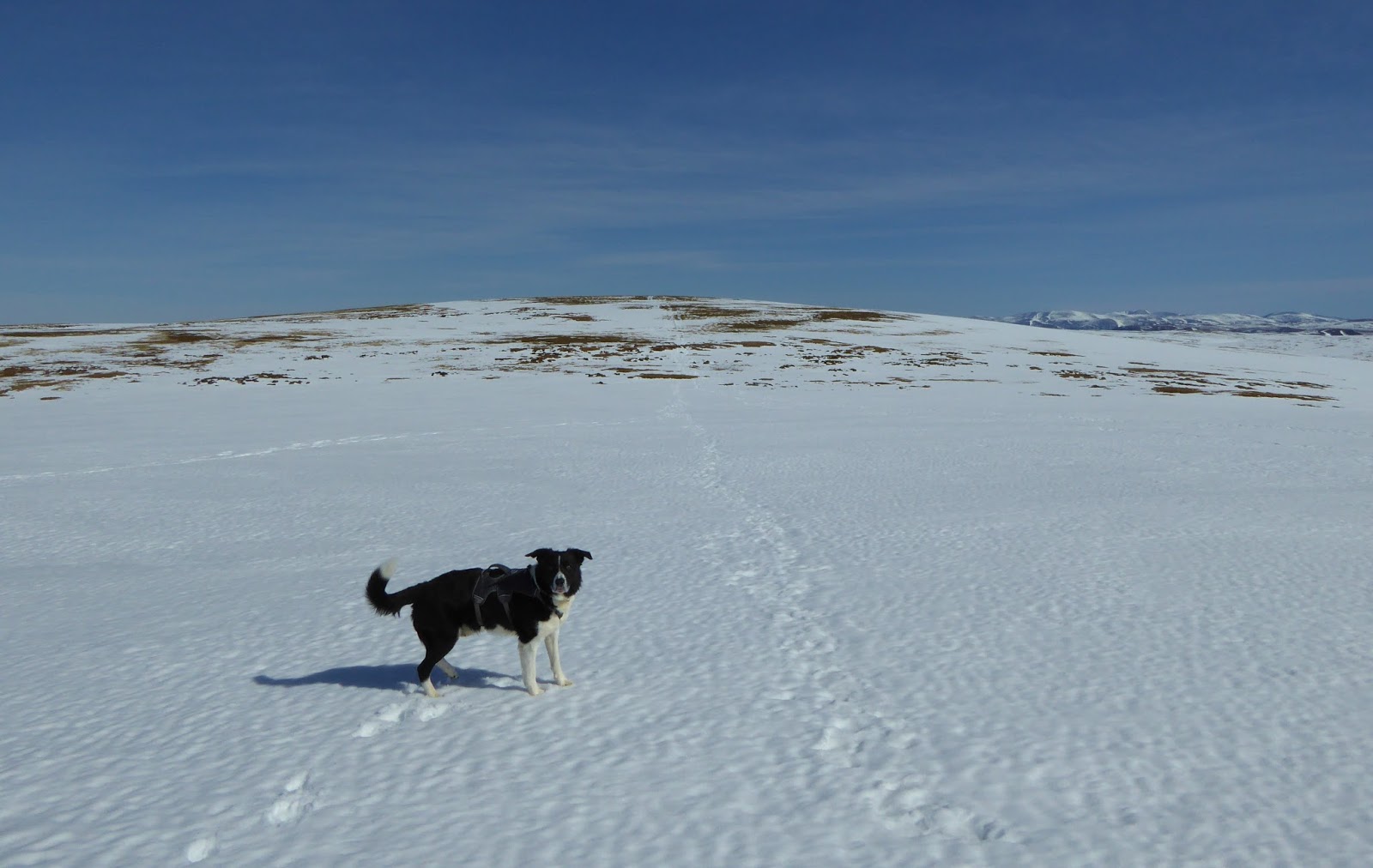
Golden plover near Carn na Caim

There were a few people about, enjoying the early spring sunshine and the perfect mountain day. We were lucky enough to catch a glimpse of a golden plover, calling across the heights.

Rafe and Jim - Ascent of Carn na Caim

The white stuff was deep enough and soft enough to be hard work - we chose to follow a route through the snow that had cut by earlier walkers...

A beautiful day on Carn na Caim

Jim - Nearing Carn na Caim summit - Rafe's already there!
(Munro 233, 941m)

Most of the snow had blown off the summit of Carn na Caim (Munro 233, 941m) - Rafe made bee line for the summit cairn getting there well before us - standing and laughing at the slow coaches.

Views north from Carn na Caim summit to Loch Cuaich and Meall Cuaich

The views were wonderful again - across to the north east was Meal Cuaich, climbed last March and west to Ben Alder.

Ben Alder and friends from Carn na Caim

Jim - heading back (south) towards spot height 902m (NN660801)
from Carn na Caim

Our route now took us back across the plateau to the 902m spot height again...

Views west to Drumochter Munros and Ben Alder massif from spot height 902 (NN660801)

We were soon crossing new ground, south east across the minor dip between ABhuidheanach and A'Bhuidheanach Mhor - it didn't look far, but perspective is difficult on these rolling heights.

Views over Coire Chuirn to Sgairneach Mhor and A'Mharconaich

The snow was softening further in the warm sun - the walking was hard work...

From A'Bhuidheanach to A'Bhuidheanach Mhor

But the views were superlative.

Jim - descent from A'Bhuidheanach - views to A'Bhuidheanach Mhor
(walker in the distance for perspective!)

Rafe and Jim - Ascent of A'Bhuidheanach Mhor

Rafe and Jim - Ascent of A'Bhuidheanach Bheag - other walkers at the summit cairn

There wasn't too much in the way of ascent, we continued to follow in the footsteps of other walkers ahead and we were soon nearing the summit of our second Munro of the day.

Jim and Rafe nearing A'Bhuidheanach Bheag summit

It was truly beautiful.

Views south from A'Bhuidheanach summit

The views from the summit of A'Bhuidheanach Bheag (Munro 241, 936m) opened up to the south - the whole of the southern Cairngorms and beyond to the Perthshire hills.

A'Bhuidheanach summit (Munro 241, 936m)

Many photographs were taken.

Views back (north) towards Carn na Caim

Rafe and Jim - return towards spot height 902m

We returned the way we had come, across the snow fields, tiring now - to the 902m spot height. We were avoiding the snow as much as possible, picking our way between grassy patches.

Views to Drumochter Munros and Ben Alder massif from A'Bhuidheaneach

The views were as good as ever - the changed light of the afternoon made them new again.

Rafe and Jim descent towards Glen Truim from A'Bhuidheanach plateau

We were soon back on the track back down into Glen Truim and to the A9 - so much easier now that we had gravity on our side.

Descending into Glen Truim - views west

Once beyond the snowfields the going got even easier - we cut off the corner and headed directly for the Beauly/Denny line car park - yomping through the heather.

Rafe and Jim - descend towards Glen Truim

There were a few mountain hare hopping about amongst the vegetation, their winter coats showing up bright against the brown of the undergrowth.

Mountain Hare

Views south west from descent from A'Bhuidheanach

We were soon down in the glen - basking in the later afternoon warmth - it really felt like spring.

Looking back to A'Bhuidheanach from near A9

It had been a great hill day - but one that had been rather more strenuous than we had anticipated! - all good practice...

Rafe and Jim in the Beauly/Denny Line works yard by the A9 at the end of the walk

Route:  Layby on A9 S of A889 turnoff to Dalwhinnie (NN639821), track initially NW, under pylons and through works car parking area (NN642823), continue on track (overall SE) to minor summit 902m (NN661802), N over minor summits,  892m, 914m, sh 894m following fence posts, Carn na Caim South Top (Munro Top  914m), NE to Carn na Caim (Munro 233, 941m), return to minor summit 902m, S to A'Bhuidheanach, SE to A'Bhuidheanach Mhor, SW and S along fence posts to A'Bhuidheanach Bheag (Munro 241, 936m) return to minor summit 902m, return NE to start.

Statistics:  Distance: 19km  Ascent: 850m  Time: 6 hours

Map:  OS Explorer 394 Atholl

Carn na Caim

A'Bhuidheanach Bheag

Beinn Bhrotain and Monadh Mor

Setting off from Glen Feshie - it was chilly - before the sun had a chance to peep over the hills...  Off we go! Jim - Setting off near Auch...