Great forecast. Go west...
 |
| Bla Bheinn and Garbh-bheinn over Loch Slapin from Torrin |
We set off from the car park beside the Broadford to Elgol road beside Loch Slapin, taking in the glorious views of Skye about us - seriously excited about the prospects for an excellent hill day.
And what an excellent day it turned out to be!
 |
| Bla Bheinn from the car park beside the B8083 |
The path was good, recently improved by The John Muir Trust's dedicated volunteers, towards
Bla Bheinn, through the gold and umber autumn grasses - easy walking.
 |
| Bla Bheinn from the path at the start of the walk |
The Allt na Dunaiche tumbled across the moor, through gorge and over waterfall and the path followed its course, a gradual and comfortable ascent.
 |
| Waterfalls on Allt na Dunaiche |
 |
| Looking back along the Allt na Dunaiche |
 |
| Waterfalls on Allt ns Dunaiche with Bla Bheinn beyond |
 |
| Rafe and Jim - Nearing the start of the ascent into Coire Uaigneich |
The crags of Bla Bheinn got gradually nearer.
 |
| Rafe has a plodge in Allt na Dunaiche |
There was a short steep pull up Coire Uaigneich right under the crags - it was here that the improvements to the path were most appreciated, easy steps - and we were soon stepping out into the grassy bowl of Fionna-choire.
 |
Looking back from the ascent into Coire Uaigneich
Views to Loch Slapin and Beinn na Caillich |
 |
| Jim - Ascent into Coire Uaigneich - views to An Stac |
 |
| Jim and Rafe - Coire Uaigneich |
 |
| Views back (east) into Coire Uaigneich to The Red Cuillin |
 |
| Views south over Loch Fionna-coire |
We could see other walkers ahead of us, heading across the coire floor, making a bee line for the zig zags visible at the far western end.
That wasn't our route today - as soon as were were past the steep rocks on our right, we took an indistinct path, up, beside Bla Bheinn's eastern crags, marked by a little cairn.
 |
Jim - Fionna-choire - views west to bealach between
Slat Bheinn and Bla Bheinn |
We stopped for a first lunch, sitting on some convenient rocks, not far above the coire and took in the breathtaking arena around and above us. We didn't stop for long, we wanted to get on...
 |
| Views south east from the start of the ascent out of Fionna-choire |
 |
| Jim - ascent of Bla Bheinn out of Fionna-choire |
The path soon became more obvious - initially there were zigzags through fairly steep scree.
 |
| Jim - ascent of Bla Bheinn |
Once bejond the initial scree slog, we kept towards the edge of the crags, undertaking a bit of easy scrambling when it was offered.
 |
| Views back (south east) from start of the ascent out of Fionna-choire |
And the views! No words...
 |
| Views south east over Loch Slapin, from ascent of Bla Bheinn south east face |
 |
| Clach Glas from ascent of Bla Bheinn |
 |
| The Great Prow, Garbh-bheinn and Clach Glas from ascent of Bla Bheinn |
 |
| Craggy bits - ascent of Bla Bheinn |
 |
| Loch Slapin from ascent of Bla Bheinn |
 |
| Views back down our route into Fionna-choire and over Loch Slapin |
 |
| Views east over the Red Cuillin from ascent of Bla Bheinn |
 |
| Jim - beside the Great Prow |
 |
| The Great Prow and Garbh-bheinn from the ascent of Bla Bheinn |
 |
| Views east from Bla Bheinn |
 |
| Clach Glas from the ascent of Bla Bheinn |
 |
| Jim - Ascent of Bla Bheinn |
 |
| Bla Bheinn's eastern cliffs and Loch Slapin |
 |
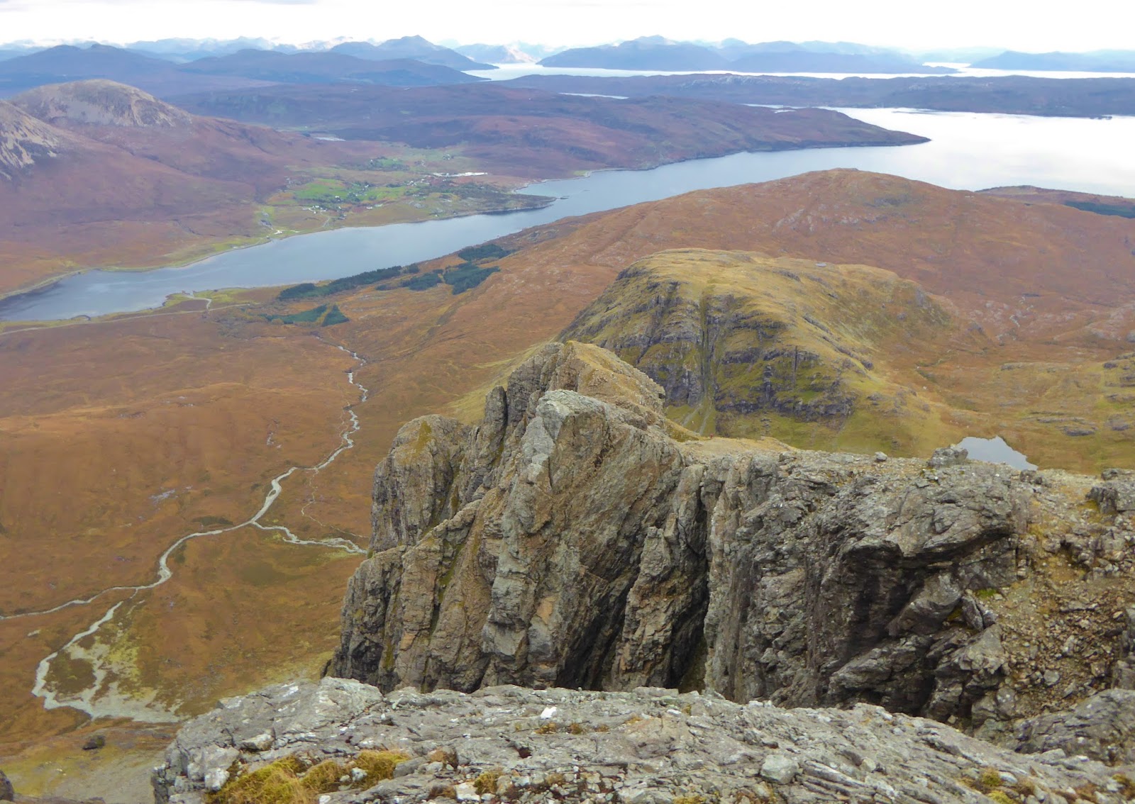
| Views north over Red Cuillin and Garbh-bheinn from ascent of Bla Bheinn |
 |
| Rafe - ascent of Bla Bheinn |
 |
| Jim - ascent of Bla Bheinn |
 |
| Views north as we near the summit of Bla Bheinn |
There's not many hills when you don't want the ascent to finish.
 |
| Jim and Rafe - the final pull to Bla Bheinn summit |
 |
| North from the ascent of Bla Bheinn |
There was a bit of whispy cloud hanging over the summit as we climbed the final few metres, but this soon took itself off to hang around the rugged summits of the Black Cuillin instead.
 |
| Jim nears the summit - Bla Bheinn |
There were a couple of glossy ravens on the summit, looking to share our sandwiches...
 |
| Raven near Bla Bheinn summit |
We took about one hundred photographs...
 |
| Black Cuillin and Glen Sligachan from Bla Bheinn |
Bla Bheinn (Munro 252, 928m) is the most amazing viewpoint!
 |
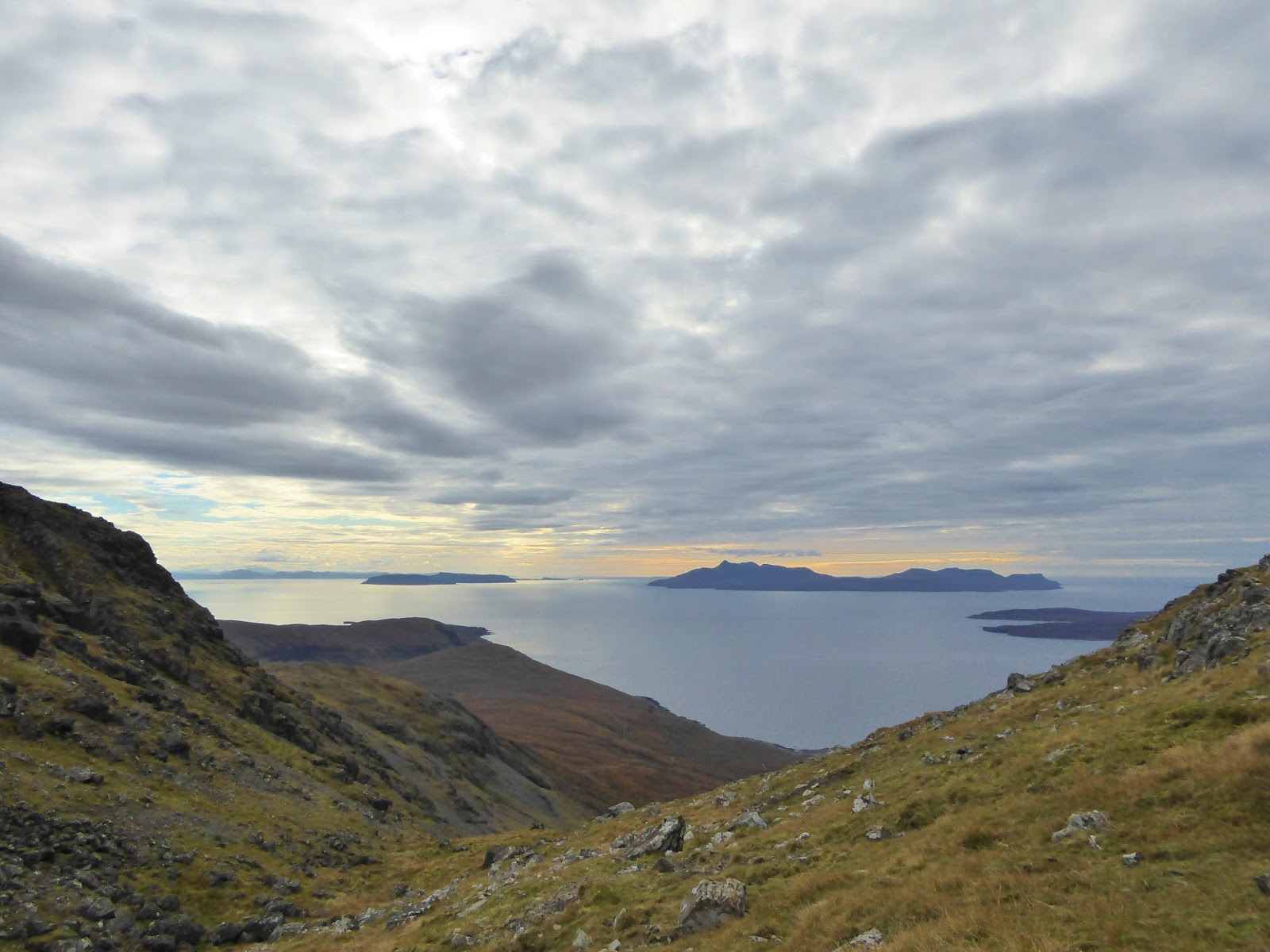
| Over the Sount of Sleat to Knoydart from Bla Bheinn |
We got tucked behind some rocks, out of the rather chilly wind (it is the end of October!) and had a second lunch. The Black Cuillin loomed precipitously over Glen Sligachan in front of us - we watched the cloud wending its way around the summits whilst we tried to identify the different points.
 |
| Bla Bheinn summit (Munro 252, 928m) - views north |
 |
| Black Cuillin, Glen Sligachan and Red Cuillin frmo Bla Bheinn |
We wandered on, west across a minor bealach, with more wonderful views. This time, to the Small Isles.
 |
| Rafe and Jim - Bla Bheinn summit - views to Bla Bheinn South West Top |
 |
| The Black Cuillin from Bla Bheinn |
 |
| The Red Cuillin from Bla Bheinn |
 |
| Rafe and Jim - descent from Bla Bheinn - views to South West Top |
 |
| Loch Slapin and Sound of Sleat from Bla Bheinn |
 |
| Sleat with Knoydart beyond from Bla Bheinn |
 |
| Jim - scrambly bits on Bla Bheinn South West Top |
There was a bit of a scramble up to Bla Bheinn's South West Top - up a ledge and round a boulder. This would have been fine if we didn't have our four legged friend, but even with his harness, we couldn't quite get Rafe around the boulder.
 |
| Rafe has a bit of a scramble on Bla Bheinn South West Top |
Jim had to take Rafie back to the bealach and find another route - there was a handy shute just below the ledge - but Rafe still needed a helping hand up the steepest bit.
 |
| Eigg, Rum and Soay from Bla Bheinn South West Top (Munro Top 196, 926m) |
 |
| The Black Cuillin and Glen Sligachan frmo Bla Bheinn South West Top |
More expansive views from Bla Bheinn South West Top (Munro Top 196, 926m).
 |
| Jim - Descent from Bla Bheinn South West Top -views south over the Sound of Sleat |
The descent into the bealach to the south was a long scree and boulder hopping slog. I'm really glad we didn't ascend that way.
The views were never ending though.
 |
| Bealach between Bla Bheinn SW Top and Slat Bheinn |
We were soon down in the bealach. Rafie had the obligatory plodge in the lochan.
 |
| Looking back (north west) to South West Top and Bla Bheinn |
We just weren't ready to head down yet. We decided to pop up Slat Beinn, the minor top (a Sim) to the south.
 |
| Views south west from bealach between Slat Bheinn and Bla Bheinn |
 |
| Jim and Rafe - ascent of Slat Bheinn |
It really wasn't very far. And once again the views were far reaching.
 |
| Rum from Slat Bheinn |
 |
| Jim - Slat Bheinn - views east |
I wandered about on the summit of Slat Bheinn (624m) taking more pictures, back to Bla Bheinn, across to the mainland, of myriad islands - whilst Jim sauntered across the summit...
 |
| Bla Bheinn from Slat Bheinn |
...before running back towards me gesturing to hurry. Just over the bank, on the rocky eastern slopes of Slat Bheinn, was a golden eagle standing on a boulder, just 10 metres or so, away from us.
 |
| Golden eagle - Slat Bheinn |
We all (including Rafie) stood and watched in awe. S/he sat there, surveying her domain - particularly interested in walkers coming down the zigzags from Bla Bheinn on the other side of Fionna-choire (the way we had gone up). S/he seemed unaware that we were there and we were able to watch for several minutes before s/he decided to take herself off, to soar above the coire, then away to the east.
 |
| Bla Bheinn and Loch Foinna-choire |
Jim and I continued our descent into Fionna-choire with big grins on our faces. It really put a cap on an already great day.
 |
| Bla Bheinn from descent from Slat Bheinn (zig zag ascent route right of centre) |
We stopped for a bite beside Loch Fionna-choire - a mirror for the sky - and watched the shadows move across the mountains of the mainland.
 |
| Third lunch by Loch Fionna-coire |
We dropped into the upper gorge of Coire Uaigneich and followed the burn east for a while, until the we neared the path.
 |
| Descent via Coire Uaigneich |
Clambering out of the gorge, we took the easy route back, across the moor, past the waterfalls and the golden autumn back to the car and a welcome cuppa.
 |
| Back on the path - descent from Fionna-coire |
What a day...
 |
| Beside the Allt na Dunaiche - descent towards Loch Slapin |
Route: John Muir Trust car park by B8083 Broadford/Elgin road (NG560215), fp back to road, N across road bridge over Allt na Dunaiche, immediately W along good fp along N bank of burn and ascend into Coire Uaigneich, once into Fionna-choire, just past the crags (NG536212), turn sharp N at a small cairn and follow zig zag very rough path above cliffs and crags to Bla Bheinn summit (Munro 252, 928m), W to Bla Bheinn South West Top (Munro Top 196, 926m), descend SE steeply on scree to bealach (NG533209), SE to Stat Bheinn summit (624m), E then N avoiding crags to Loch Fionna-choire (NG537211), NE picking way across gorge to path at NG538213 approx, return E to start.
Statistics: Distance: 9km Ascent: 1050m Time: 6 hours
Map: OS Explorer 411 Skye - Cuillin Hills